
- Account
-
- NEW ARRIVALS
- Men
-
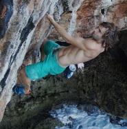
Core Climbing Apparel from prAna
Shop Now »
- Women
-
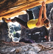
Patagonia Offers Versatility and Comfort for all your Adventures
Browse Patagonia »
- Kids
- Gear
- Snow Sports
-
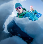
Stay Safe in the Backcountry
Shop Ortovox»
- Paddle Sports
-
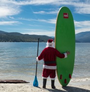
Santa Knows How to Enjoy His Off-Season
Shop Red Paddle »
- DEALS
Providing a detailed overview of Kootenay National Park in BC, this recreation map highlights all the main roads and trails, campsites, hot springs and notable recreation areas, backroad attractions, larger lakes and river systems, paddling routes and more! Shown at 1:120,000 scale, this map features topographic relief shading and is the perfect planning tool for exploring this breathtaking park. Included on this map are Kootenay Crossing, Radium Hot Springs, Vermillion Crossing, Brisco Range, East Kootenay Fire Road, Great Divide Trail, Hawk Creek, Hector Gorge, Highway 93, Kindersley Creek, Kootenay River, Marble Canyon, Mount Sinclair, Numa Pass, Ochre Creek, Redstreak Campsite, Simpson River, Stanley Glacier, Vermillion River and more!
Material:
* Printed on regular water-resistant paper
Specs:
* Dimensions: 61 x 94 cm / 24 x 37 In
* Maps: 1:120,000
Features:
* Large-scale printed or digital maps that are easy to read
* Seamless map coverage that requires no page turning
* Industry-leading cartographic detail and topographic relief shading and contour intervals
* Multi-use trail systems and trailheads for hiking, horseback riding, mountain biking, cross-country skiing and snowshoeing
* Motorized trail systems for ATVing, off-roading and snowmobiling showing trailhead & staging locations
* Paddling routes including portages, campsite locations and number of tent sites
* Includes National, Provincial and Regional Parks including campsites and day-use locations
* Highlighted park boundaries along with Crown & private land areas
* Hundreds of land and water geographic features
* UTM grids with latitude and longitude make navigating the map easy
* Areas Covered: Kootenay National Park, Kootenay Crossing, Kootenay Parkway, Marble Canyon, Radium Hot Springs, Rockwall Trail, Simpson River, Vermilion Crossing, BC, Canada
* Map Features: Highways, Logging Roads, Land & Water Features, Parks, Adventure Points of Interest, Campgrounds, Hiking Trails, Motorized Trails, Paddling Routes, Hunting & Fishing Areas, Winter Recreation and More..


How Adventure Bucks Work
Earn Adventure Bucks every time you make a purchase*! Even 'on sale' items, in-store or online at VPO.ca. Each Adventure Buck is worth $1, so figure out what you want to buy!
You can redeem your Adventure Bucks at anytime:
- InStore: Ask the staff to apply your Bucks to your purchase.
- Online: Enter the amount of Bucks you wish to redeem in the Payment tab to apply them to your online order.
- *Arc'teryx items are excluded
Shipping Information
We Ship Anywhere Within Canada
Signature Required & Faster Shipping Options
All parcels are shipped ground with a signature required. If you want your order quicker, give us a call at 1-800-SHOP-VPO for a quote. Prices are in Canadian dollars. We will ship your order via Purolator Ground or Canada Post Regular Parcel . If you prefer one method over another, please make note in the notes/delivery instructions when you checkout.
Free Shipping
FREE shipping on orders totaling $49 or more before taxes.
NOTICE: THIS ITEM WILL BE DELAYED BY 5-12 BUSINESS DAYS.
| Destination | Estimated Arrival |
| Western Canada | 5-15 business days |
| Central Canada | 7-17 business days |
| Eastern Canada | 9-21 business days |
* We use Purolator for majority of our shipments. If you live in a rural area, Northern Canada, the Maritimes, or we have to use Canada Post for delivery, please note that the estimated arrival time may be longer.
Oversized or Overweight Item
This item is subject to a shipping surcharge
Unfortunately due to the size or weight of this item, we are required to apply a shipping surcharge when you order this item. To read our full shipping and freight policy, please click here.
Sorry, the real-time inventory lookup is not available at this time.
Sorry, the colour and size you selected is not available.
Colour & size selection available at: