
- Account
-
- NEW ARRIVALS
- Men
-

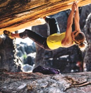
Core Climbing Apparel from prAna
Shop Now »
- Women
-
Patagonia Offers Versatility and Comfort for all your Adventures
Browse Patagonia »
- Kids
- Gear
- Snow Sports
-
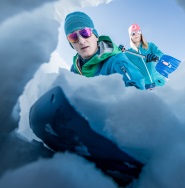
Stay Safe in the Backcountry
Shop Ortovox»
- Paddle Sports
-
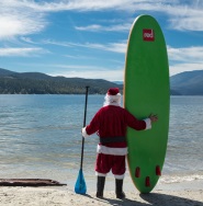
Santa Knows How to Enjoy His Off-Season
Shop Red Paddle »
- DEALS
GemtrekBanff Up Close - 3rd Edition

Gem Trek’s BANFF UP-CLOSE MAP is waterproof and tear-resistant. It is primarily designed for visitors who are going to be in Banff for a short period of time and want to make the most of their stay. The main map is a detailed relief-shaded topographic map of the Banff area. All hiking and biking trails are labeled, and distances are marked.
Like all Gem Trek maps, the Banff Up-Close Map features detailed cartography and accurate hiking trails with distances, elevation gain, and directions to the trailhead noted. On the back of the map are descriptions of the sights, museums and scenic drives in Banff, with hours of operation and admission fees noted to make it easier to plan your day. We've also included a hand-picked list of the best seven walks and day hikes in the area. The highlights of each trail are noted, as well as distance, elevation gain and directions to the trailhead.
Banff Up-Close Map Coverage:
The Banff Up-Close Map focuses its coverage on the town of Banff. It extends from the Sunshine Village turnoff in the west, to Lake Minnewanka in the north and east, to the Banff Gondola in the south.
Popular hiking trails on the Banff Up-Close Map include Sundance Canyon, Stewart Canyon, the Hoodoos, Tunnel Mountain, and Cory Pass. The map also has detailed information on the town’s museums and historic sites.
An inset on the back increases coverage of downtown Banff, with museums and all major streets marked.
Gemtrek
"http://schema.org/NewCondition"
Out Of Stock
Out of Stock: Banff Up Close - 3rd Edition

Uh-oh! We’re sorry, but This product is no longer in stock.
But don’t worry! We have lots of other great products available to fit your needs. Browse Similar Products


Sorry, the real-time inventory lookup is not available at this time.
Sorry, the colour and size you selected is not available.
Colour & size selection available at: