
- Account
-
- NEW ARRIVALS
- Men
-

Core Climbing Apparel from prAna
Shop Now »
- Women
-

Patagonia Offers Versatility and Comfort for all your Adventures
Browse Patagonia »
- Kids
- Gear
- Snow Sports
-
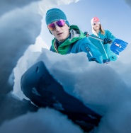
Stay Safe in the Backcountry
Shop Ortovox»
- Paddle Sports
-
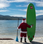
Santa Knows How to Enjoy His Off-Season
Shop Red Paddle »
- DEALS
This tear-resistant, waterproof map of the East Kootenay region is easy to use and carry on all your outdoor adventures. Our newest edition of the map includes industry-leading topographic detail, unparalleled road coverage and countless trails, rec sites, and paddling routes, along with labelled fish species and stocked fishing lakes and rivers. Numerous updates and expansions from our last edition include added private leased lands and more clearly defined camping areas, making this the most up-to-date topographic map available for the East Kootenay region!
Tucked away in BC's southeastern corner is one of the province's most exciting outdoor adventure destinations the East Kootenays are a land of deep lakes, crystal-clear rivers, towering mountains and wide-open valleys. This waterproof recreation map charts the entire region, from the healing waters of Radium Hot Springs to the mountain playground around Fernie, the wilderness of the Purcell Range and beyond. We have expanded the map coverage north to include all of Banff National Park in Alberta, more of the Flathead area, the area north of Golden, and even a portion of the West Kootenays. Printed on durable, water-resistant material and loaded with industry-leading cartographic detail, this is your ultimate guide to one of Canada's premier outdoor recreation areas.
This tear-resistant, waterproof map of the East Kootenay region is easy to use and carry on all your outdoor adventures. Our newest edition of the map includes industry-leading topographic detail, unparalleled road coverage and countless trails, rec sites, and paddling routes, along with labelled fish species and stocked fishing lakes and rivers. Numerous updates and expansions from our last edition include added private leased lands and more clearly defined camping areas, making this the most up-to-date topographic map available for the East Kootenay region!
Specs:
* Released: 2022
* ISBN #: 978-1-989175-24-8
* Pages: 2
* Paper: Waterproof, Tear-resistance
* Dimensions: 86 x 117 cm (34 x 46.25 inches)
* Maps: 2 sides @ 1:200,000
* Digital Format Available: Yes, see the Digital tab for details.
* Map Features: Highways, Logging Roads, Land & Water Features, Parks, Adventure Points of Interest, Campgrounds, Hiking Trails, Motorized Trails, Paddling Routes, Hunting & Fishing Areas, Winter Recreation and More.
* Areas Covered: Banff, Canal Flats, Canmore, Cranbrook, Creston, Elkford, Fairmont Hot Springs, Fernie, Flathead, Golden, Invermere, Kimberley, Kootenay Crossing, Lake Louise, Parson, Radium Hot Springs, Rogers Pass, Sparwood, Yahk, and more
Features:
* Easy-to-read maps derived from our Backroad Mapbooks at 1:200,000 scale
* Industry-leading cartographic detail and topographic relief shading
* Addition of private leased land keeps you in bounds while exploring the wilderness by foot, bicycle, ATV or truck
* The most complete recreation, industry and county road coverage available for the East Kootenay region
* Thousands of kilometers of trail systems for ATVing, paddling, snowmobiling, hiking, mountain biking, cross-country skiing and snowshoeing
* Highlighted Wildlife Management Units (WMUs) for anglers and hunters
* Labeled fish species and stocking information for fishing lakes and rivers
* Area features such as Regional Districts, Ski Resorts, Mountain Caribou motorized restricted areas, First Nations, Private and Leased Land, and more
* UTM grids with latitude and longitude make navigating the map easy
* Hundreds of land and water geographic features
* National, Provincial and Regional Parks and Campsites
* Detailed index for recreation sites, trails, and provincial parks
* Trail charts for National Parks including Banff National Park, Kootenay National Park, Glacier National Park, and Yoho National Park
* List of all the best local outdoor retailers and outfitters
Digital Features:
* Offline Maps: cell service or Wi-Fi is not necessary to view the maps
* GPS tracking: track your route while you are out on an adventure
* Marking waypoints: save different points and locations to visit or use to plan routes
* Easy to Read: zoom into specific points on the map or zoom into text for easier reading
* Lightweight: transport several maps at once using your smartphone or tablet
* Easy to Navigate: download our maps from your favorite 3rd party app and easily scroll through the maps, zoom in and out, and use the GPS features to navigate
* Eco-Friendly: zero paper waste!
How Adventure Bucks Work
Earn Adventure Bucks every time you make a purchase*! Even 'on sale' items, in-store or online at VPO.ca. Each Adventure Buck is worth $1, so figure out what you want to buy!
You can redeem your Adventure Bucks at anytime:
- InStore: Ask the staff to apply your Bucks to your purchase.
- Online: Enter the amount of Bucks you wish to redeem in the Payment tab to apply them to your online order.
- *Arc'teryx items are excluded
Shipping Information
We Ship Anywhere Within Canada
Signature Required & Faster Shipping Options
All parcels are shipped ground with a signature required. If you want your order quicker, give us a call at 1-800-SHOP-VPO for a quote. Prices are in Canadian dollars. We will ship your order via Purolator Ground or Canada Post Regular Parcel . If you prefer one method over another, please make note in the notes/delivery instructions when you checkout.
Free Shipping
FREE shipping on orders totaling $49 or more before taxes.
NOTICE: THIS ITEM WILL BE DELAYED BY 5-12 BUSINESS DAYS.
| Destination | Estimated Arrival |
| Western Canada | 5-15 business days |
| Central Canada | 7-17 business days |
| Eastern Canada | 9-21 business days |
* We use Purolator for majority of our shipments. If you live in a rural area, Northern Canada, the Maritimes, or we have to use Canada Post for delivery, please note that the estimated arrival time may be longer.
Oversized or Overweight Item
This item is subject to a shipping surcharge
Unfortunately due to the size or weight of this item, we are required to apply a shipping surcharge when you order this item. To read our full shipping and freight policy, please click here.
Sorry, the real-time inventory lookup is not available at this time.
Sorry, the colour and size you selected is not available.
Colour & size selection available at: