About God's Pocket:
* The highway north through Vancouver Island ends abruptly at Port Hardy, 500 km north of Victoria. But in another sense it is just a beginning, a gateway to marine routes including British Columbia’s vast north and central coasts. Off Port Hardy lie Queen Charlotte Strait and Queen Charlotte Sound, two intimidating bodies of water on the edge of the Great Bear Rainforest, the name given by environmentalists to add a poetic touch to campaigns to protect British Columbia’s embattled forest coastland. But visitors needn’t go far to touch on what makes the remote BC coast so intriguing. Within just a few kilometres of Port Hardy are numerous straits, channels, islets, reefs and several pocket archipelagos that give a sense of what the wild and remote British Columbia coast is all about. And for those seeking real adventure, it is also the route to Cape Scott and the wild northern tip of Vancouver island. This gives the potential for a double holiday covering two very different types of coastal environments.
About this mapsheet:
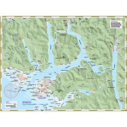
* This mapsheet packages the waters from Fort Rupert, just east of Port Hardy to Shushartie Bay to the west. This includes God's Pocket Marine Park, Goletas Channel, Deserters-Walker Groups, Nigei Island, Bate Passage, Vansittart Island and all archipelagos and locations leading from Port Hardy to the east entrance to Cape Scott Provincial Park. Use in conjunction with mapsheet #407 North Coast Trail for the current west extension. Eventually #244 Cape Scott will cover the marine travel portion of that route.
The mapsheet layout:
* The layout is a regional overview on the full page of one side, and on the other side a detailed package of trip planning information.
The mapsheet construction:
* The mapsheet is created by Wild Coast Publishing using some of the latest technology available to provide a high-quality printed image on waterproof/durable synthetic polymer stock. The stock is picked as the best for the purpose, and is significantly thicker than most papers at 10 mil weight.
Sorry, the real-time inventory lookup is not available at this time.
Sorry, the colour and size you selected is not available.

